





















TL;DR:
- Travelers should use an interactive tourist map for planning and a printable high-resolution map for offline reference. A combination of Egyptra for POIs, Google Maps for navigation, and CIA maps for printouts ensures comprehensive guidance across Egypt. Layering digital and physical maps, along with an active eSIM, provides reliable navigation in remote areas and checkpoints.
For most travelers, the right starting point is an interactive tourist map for routing and POI discovery, backed by a printable high-resolution administrative map for offline reference. Three sources cover the majority of planning needs: the Egyptra interactive tourist map for itineraries, Google Maps for live navigation, and the Perry-Castañeda Map Collection at the University of Texas for authoritative printable downloads.
Quick source match:
- Routing and navigation: Google Maps
- Itinerary planning and POIs: Egyptra interactive tourist map
- Printable backup: Perry-Castañeda / CIA maps (8.5x11, print-ready)
Table of Contents
- What are the best Egypt map sources for travelers?
- Which map type should you use for each trip?
- How do you plan routes and estimate travel times in Egypt?
- How do you download, print, and use Egypt maps offline?
- How does an eSIM keep your Egypt maps working?
- Key Takeaways
- The map workflow that actually holds up in the field
- Reliable mobile data for your Egypt maps
- Useful sources and downloads
- FAQ
What are the best Egypt map sources for travelers?
Egypt is a large country stretching primarily north to south with an extensive land area. Nearly all tourist infrastructure concentrates along the Nile Valley and the Red Sea and Sinai coasts, so map quality along those corridors matters far more than coverage of the interior desert.
Egyptra Interactive Tourist Map marks cities, ancient sites, and regional attractions with categorized POIs. Each marker links to photos, travel tips, and tour options. Filtering by interest type (ancient sites, beaches, diving) speeds up itinerary building considerably.
Google Maps handles live turn-by-turn navigation, walking directions, and real-time traffic. It also supports offline area downloads, covered in detail below.
Perry-Castañeda Map Collection (University of Texas) hosts downloadable Egypt maps produced by authoritative agencies. Administrative, physical, and transport maps are available for free download and printing. The collection carries strong academic credibility.
CIA Maps publish administrative, physiography, and transportation maps of Egypt, all formatted to print cleanly on 8.5x11 paper. These are government-sourced references, useful for checkpoint-ready printed copies.
Wikimedia Commons hosts high-resolution SVG location maps (such as Egypt_location_map.svg) with embedded geographic limits and projection metadata. Files are free to download and reuse with attribution.
Nations Online provides a political map showing all governorates, major cities, main roads, railroads, and airports. Useful for understanding administrative boundaries before booking regional transport.
WorldAtlas offers downloadable physical and outline maps, plus country facts including regional coordinates and bodies of water.
Which map type should you use for each trip?
Different map types solve different problems. Matching the right type to the task saves time in the field.
- Interactive tourist map: — POIs, tours, and itinerary sequencing. Best for first-time planners building a Cairo-to-Aswan route.
Egypt’s tourist activity clusters along two corridors: the Nile Valley (Cairo, Luxor, Aswan, Abu Simbel) and the Red Sea and Sinai coasts (Hurghada, Sharm el-Sheikh, Dahab). A physical map clarifies why those corridors exist; an interactive tourist map tells you what to do once you’re there.
Pro Tip: For print, choose a map scale that fits the region you’re covering. A full-country administrative map at 1:4,000,000 works for overview planning. For city-level navigation, use a 1:50,000 or larger scale map and print at 300 DPI for outdoor readability.
How do you plan routes and estimate travel times in Egypt?
Start with flight time as the baseline, then compare train and drive times to decide what fits your schedule.
| Route | Flight | Train | Drive |
|---|---|---|---|
| Cairo to Luxor | ~1 hr | 10 hrs | 10–12 hours |
| Cairo to Aswan | 1.5 hours | — | ~— |
| Luxor to Aswan | N/A (short) | ~3–4 hrs | 3.5 hours |
| Cairo to Hurghada | ~1 hr | N/A | 5–6 hours |
| Cairo to Sharm el-Sheikh | ~1 hr | N/A | ~7–8 hrs |
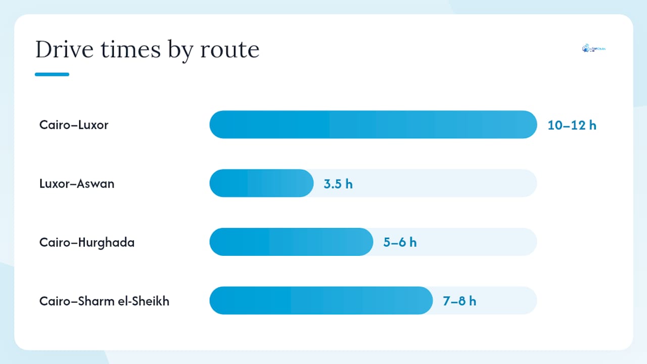
Flights make sense for the Cairo-to-Aswan leg when time is short. The overnight train from Cairo to Luxor or Aswan is a practical option for travelers who want to save a hotel night and arrive rested. Driving gives flexibility for Red Sea coastal stops but requires awareness of checkpoint locations.
Interactive maps show estimated drive times dynamically and let you layer POI markers to sequence a day’s stops. Static printed maps require manual distance calculation using the scale bar, which is slower but works without data.
For Red Sea coastal route planning, Red Sea yacht charter options add a water-based routing dimension worth factoring into itineraries along that coast.
Pro Tip: Book overnight trains at least two weeks ahead during peak season (October through April). Sleeper berths sell out fast, and the schedule affects which cities you can realistically map into a single loop.
How do you download, print, and use Egypt maps offline?
The fastest offline setup combines a Google Maps offline area download with a printable high-res PDF for reference at sites with no signal.
- Download a Google Maps offline area. Open Google Maps, search for the region (e.g., “Luxor”), tap the location name, then select “Download.” Choose the area boundary and confirm. The download covers navigation and POIs without a data connection.
- Download a printable PDF. Go to the Perry-Castañeda Collection or the CIA Maps page and download the Egypt administrative or transport map. Save to cloud storage (Google Drive or iCloud) and also to your phone’s local storage.
- Print at 8.5x11. Set print resolution to 300 DPI. Use color for terrain maps and grayscale for administrative maps to save ink. Include the scale bar and legend on every printed sheet. Font size in the legend should be at least 8–10 pt for outdoor readability.
- Install Maps.me or a similar offline app. Download the Egypt map pack inside the app before departure. Maps.me uses OpenStreetMap data and works fully offline for walking and driving navigation.
- Export GPX or KML for GPS devices. If you carry a dedicated GPS unit, export waypoints from Google Maps or a planning tool and import the file into the device before leaving your hotel.
File management tips:
- Name PDF files clearly (e.g., “Egypt-Admin-Map-CIA.pdf”) for fast access at checkpoints
- Back up all PDFs to cloud storage so you can re-download if the phone is lost
- Egypt map packs in offline apps typically run 200–400 MB; check storage before downloading
How does an eSIM keep your Egypt maps working?
Interactive maps require a data connection to load tiles, update traffic, and pull POI details. A prepaid Egypt eSIM installed before arrival keeps those functions running without roaming charges.
Install checklist:
- Confirm your device supports eSIM (Settings > General > About > Available SIM or equivalent)
- Purchase and activate the Esimglobe Egypt plan; the QR code arrives by email instantly
- Scan the QR code and follow the carrier setup prompts
- Check APN settings if data does not connect automatically
- Test speed and GPS accuracy in a mapped area before leaving the airport
Esimglobe offers Egypt-specific plans including a 100MB 7-day option for short stays with light map use, and an Egypt Unlimited Day Pass for travelers who rely on interactive maps throughout the day. For a full comparison of plan options, the best eSIM plans for Egypt guide covers current options in detail.
Data conservation tips while mapping:
- Pre-download offline areas over Wi-Fi at the hotel
- Set map apps to use cached tiles first
- Reduce map update frequency in app settings when in low-signal areas
Pro Tip: Test your eSIM data connection at the Cairo airport before leaving the arrivals hall. If the connection fails, airport Wi-Fi is available to troubleshoot activation before you need live navigation.
Key Takeaways
The most reliable Egypt map setup pairs an interactive tourist map for planning with a printable administrative map and a working eSIM for live navigation.
| Point | Details |
|---|---|
| Use interactive maps for planning | Egyptra and Google Maps handle POI filtering and route sequencing before and during the trip. |
| Print an 8.5x11 backup | Download CIA or Perry-Castañeda maps at 300 DPI; include scale bar and legend on every sheet. |
| Download offline areas before departure | Google Maps and Maps.me offline packs work without data; update them the day before you fly. |
| Carry digital and printed documents | Store passport scans with map PDFs; checkpoints at remote sites like Abu Simbel require ID. |
| Activate Esimglobe before arrival | An Egypt eSIM from Esimglobe keeps interactive maps live without roaming charges. |
The map workflow that actually holds up in the field
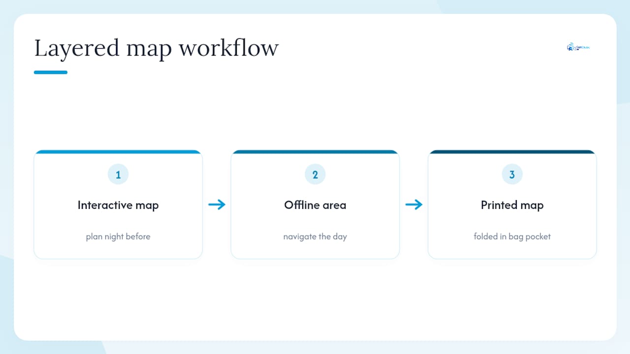
The conventional advice is to pick one map app and rely on it. That breaks down fast in Egypt, where signal drops at desert sites and checkpoints require you to show documents without warning. The workflow that holds up is layered: an interactive map for planning the night before, an offline area for the day’s navigation, and a printed administrative map folded in a bag pocket for the moments when neither works.
Planning the Cairo-to-Aswan loop with interactive markers first, then printing a transport map to track checkpoint locations, covers both the digital and the physical contingency. Neither alone is enough.
Reliable mobile data for your Egypt maps
Reliable data is what separates an interactive Egypt map from a static image. Esimglobe provides prepaid Egypt eSIM plans with instant QR code delivery by email, no physical SIM required. The Egypt 100MB 7-day plan covers light map use for short stays. The Unlimited Day Pass suits travelers who run Google Maps or Egyptra throughout the day.
Get your Egypt eSIM plan from Esimglobe before departure and arrive with data already active.
Useful sources and downloads
| Source | What it offers |
|---|---|
| Perry-Castañeda Map Collection (UT Austin) | Free downloadable Egypt maps from authoritative agencies; administrative, physical, transport |
| CIA Maps | Print-ready 8.5x11 administrative, physiography, and transportation maps; government-sourced |
| Wikimedia Commons | High-res SVG location maps with projection metadata; free to reuse with attribution |
| Egyptra | Interactive tourist map with categorized POI markers and tour links |
| Google Maps | Live navigation, offline area downloads, and real-time traffic |
| Nations Online | Political map with governorates, cities, roads, railroads, and airports |
| WorldAtlas | Downloadable physical and outline maps with country facts |
Before printing any map, check the metadata for scale and projection. CIA and Perry-Castañeda maps include this information in the file or on the map face. If you republish or share a university or government map, credit the source as listed.
FAQ
What is the best Egypt map for travel planning?
The Egyptra interactive tourist map works best for itinerary planning, while Google Maps handles live navigation. Use a CIA or Perry-Castañeda printable map as an offline backup.
Is Egypt in Africa or Asia?
Egypt is in northeastern Africa, though the Sinai Peninsula extends into Asia. Politically and geographically, Egypt is classified as an African country.
Should I bring toilet paper to Egypt?
Yes. Facilities at rural and remote sites are limited, so carrying small tissue packs is standard practice for travelers visiting sites like Abu Simbel or desert locations.
Is it safe to travel to Egypt right now?
Check the US State Department travel advisory for Egypt before departure and again before visiting remote areas. Conditions vary by region, and border areas carry higher advisories.
What was Egypt called in ancient times?
Ancient Egyptians called their land Kemet, meaning “Black Land,” referring to the fertile Nile soil. The name “Egypt” derives from the Greek Aigyptos.